Unlocking a Historic
Arizona Mining District

Kilroy Metal is deploying a modern, data-driven strategy to de-risk exploration in the historic Bradshaw Mountains. By correcting the mistakes of the past, we are systematically unlocking the true potential of the historic Blue Bell and DeSoto mines.

Explore

Smarter Exploration Starts Where Others Left Off

The Proterozoic Greenstone Belts of Yavapai County are a geological terrane of global significance, home to one of the highest-grade VMS systems ever discovered in the United States.

Kilroy Metal focuses on "brownfield" exploration—targeting historically productive mines. This approach significantly reduces risk by leveraging known mineralization, existing infrastructure, and a wealth of historical data as our foundation. We aren't just exploring; we are re-interpreting and resolving a story that is decades in the making.

Proven Geology

World-class VMS systems with established mineralization

📈

Reduced Risk

Historical production provides exploration confidence

🏗

Infrastructure

Existing access and regional mining knowledge

The Brownfield Advantage

By focusing on historically productive areas, we maximize the probability of discovery while minimizing exploration risk and timeline. Our land package was built on 45 years of expert geological analysis—not speculation.
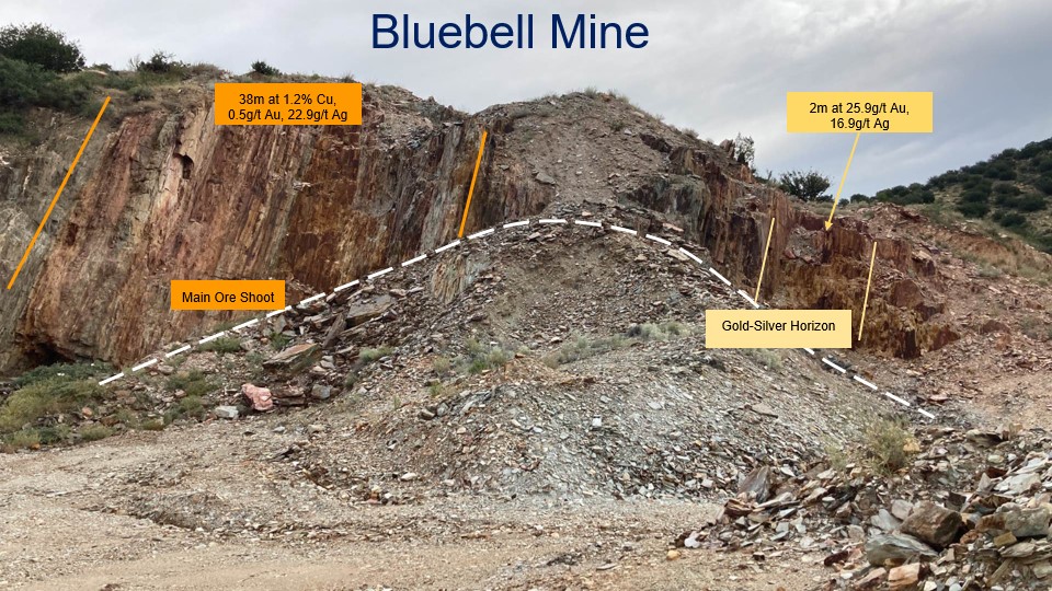
Blue Bell Mine — annotated open cut showing Main Ore Shoot and Gold-Silver Horizon with historical drill intercepts

¹ Source: AIW ASX Announcement, 31 January 2013. Historical drill hole information has been compiled from this source and reviewed in the context of the NI 43-101 Technical Report: Blue Bell and De Soto, Arizona, U.S.A. (effective November 3, 2025). This information has not been independently verified to current NI 43-101 standards and does not represent current mineral resources or mineral reserves.
Data-Driven Targeting and Precision Science

Our land package wasn't acquired by chance. We identified our initial targets based on 45 years of data collected and analyzed by a VMS expert. Today, we integrate historic production records, previous drilling results, and VTEM geophysical survey data into a unified geological model — sharpening our targeting and prioritizing the areas with the strongest evidence of mineralization.

🗄

Historic Data, Modern Analysis

Leveraging decades of geological information with advanced analytical tools to uncover patterns previous generations couldn't see.

🎯

Integrated Data Modeling

Combining historic production data, past drill results, and VTEM geophysics into a single geological model to identify and prioritize targets grounded in convergent evidence.

Strategic Acquisition

A portfolio built on expert recommendation and data-driven verification, focusing efforts where success is most probable.

This integration of historical production records, drilling data, and geophysical surveys into one working model allows us to focus our efforts on the areas best supported by the evidence, accelerating exploration decision-making.

Drilling with Purpose: A Plan to Unlock True Value

Previous exploration at sites like Blue Bell provided intriguing clues but left the geological puzzle incomplete. Historical reports and drilling often stopped short of fully defining the resource, noting mineralization but failing to model it correctly, which could lead to the dilution of high-grade material.

Our Phase 1 drill program is meticulously designed to correct these past oversights. We will systematically test for extensions of known high-grade zones and confirm the presence of a shallow, enriched chalcocite blanket—a feature identified in historical data but never fully pursued.

This isn't just more drilling; it's a strategic campaign to gather modern, high-quality data that will finally unlock the full geological and economic potential of these assets.

📋

Strategic Drill Program

  • 1
    Test for down-dip and along-strike extensions of high-grade copper zones at Blue Bell and DeSoto
  • 2
    Confirm presence and extent of shallow enriched chalcocite blanket identified in historical data
  • 3
    Apply modern drilling techniques and digital data collection for accurate geological modelling
  • 4
    Advance toward NI 43-101 compliant resource estimate framework

A Portfolio of High-Grade Polymetallic Targets

Our work is anchored by two of Arizona's most compelling past-producing polymetallic mines.

The Blue Bell Mine

Bradshaw Mountains, Yavapai County, Arizona
Blue Bell Mine

Key Highlights

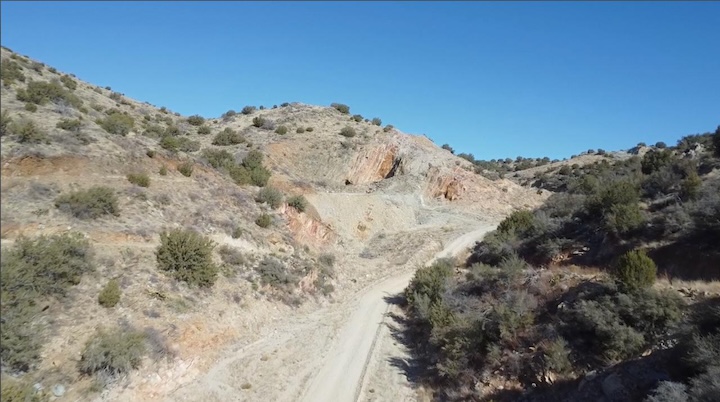
A historically significant producer with impressive average copper grades. Recent drilling has continued to encounter high-grade intercepts near the surface, demonstrating the vast potential that remains.

The DeSoto Mine

Bradshaw Mountains, Yavapai County, Arizona
DeSoto Mine

Key Highlights

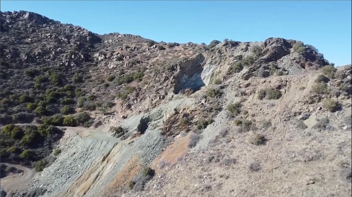
Known for its exceptionally high historic copper grades. Historic drilling identified two distinct mineralized bodies, and our modern approach is aimed at fully defining these extensive mineralized zones.

Securing the Full Six-Mile Mineralized Trend

Our strategy was never limited to the two anchor mines. From the outset, we designed a land position that locks up the entire corridor between them — protecting our ability to explore what lies in between.

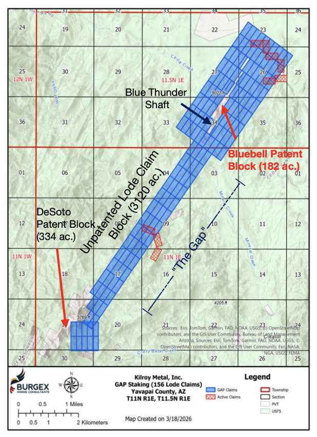
Kilroy Metal holds a lease-option on 516 acres of private patented claims spanning both the Bluebell (~182 acres) and DeSoto (334 acres) patent blocks — the highest-grade anchors in the district. Surrounding and connecting these assets, we staked 156 lode claims covering approximately 3,120 acres within the Prescott National Forest, extending the total land package to 3,636 acres across a six-mile mineralized trend.

The forest service claims serve two strategic purposes: they create a protective buffer around our private land, and they reserve the exploration opportunity in the untested ground between Bluebell and DeSoto that historical operators never pursued.

Kilroy Metal Land Package — GAP Staking 156 Lode Claims, Yavapai County AZ

Driven by Decades of Discovery and Innovation

Kilroy Metal is led by a multi-disciplinary team with deep, hands-on experience in mineral exploration, geology, and technology.

Patrick Wood

Patrick Wood

Co-Founder & CEO

Exploration and development geologist with 15 years of field-to-production experience, including roles with major operators Freeport-McMoRan (consultant) and South32. Graduate of University of Arizona and Colorado School of Mines with active academic relationships tracking advances in mining technology and engineering. Hands-on operator who has worked every exploration and mining function—from core logging to feasibility studies—giving him unfiltered clarity on what separates economic projects from commodity traps. Combines technical rigor with disciplined project advancement: understands the geological realities that drive investor confidence and the execution discipline required to de-risk and advance projects toward feasibility on accelerated timelines.

Brandon Wilson

Brandon Wilson

Co-Founder and President

Former EVP of Operations & Strategy at +100M telecom equipment manufacturer. Led multi-phase capital programs, managed cross-functional teams, and drove M&A integration. Expertise in financial discipline (budget forecasting, cash management, bank relations), operational execution, and building governance systems.

Be Part of the Next Chapter in Arizona Mining

Kilroy Metal is poised to de-risk and redefine mineral exploration in a historic American mining district. We invite you to follow our progress and connect with our team.

Contact Us

General, investor, and media inquiries welcome.

info@kilroy-metal.com
🔔

Stay Informed

Join our news feed.

Subscribe to Updates